2011年2月26日 星期六

Christchurch, New Zealand : a garden city

We are extremely saddened by the recent news of earthquake in Christchurch and its devasted damages in life and properties to the City.   

Christchurch is the largest city in the South Island of New Zealand.  It has one of the world's most beautiful botanic gardens.  The gardens cover about one third of the city area.  There is limited high rise buildings in the city.  The city government and residents make best effort to maintain their city environment as a city within the gardens.

My wife and I had opportunity to visit this lovely city before the earthquake.  We were able to take some pictures of the city and the botanic gardens. 

(Tower of the Christchurch Cathedral - now damaged by the earthquake)

(Status of John Robert Codley, founder of Canterbury - now damaged)
The Christchurch botanic gardens were first found in the 1860s.  The gardens are next to the loop of Avon River and the Hagley Park.  You can take a boat ride along the Avon River to see the city in leisure.

(Boat ride along the river)

(Century old tress welcome visitors to the gardens)

(Water fountain at the entrance of the Botanic Gardens)

The botanic gardens provide plenty of space for visitors, birds and ducks to enjoy the beautiful gardens and clear sky.  There are great collections of plants and flowers from other countries in the gardens.  The rose garden is particularly impressive with over two hundred different varieties.

(Ducks swimming along the river)

(Rose garden with glass house behind)

Inside the botanic gardens, there is a large iron bell donated by Japan.  The bell is to commorate for world peace.

(World peace bell donated by Japan)

2011年2月19日 星期六

Chinese Hakka : guest people

Hakka in Chinese means guest people.  They are part of the Han ethnic group.  Their ancestors came from Central China and migrated to the South over the past centuries.  Many of them had further migrated to other regions in Southwest China, Taiwan, Southeast Asia and other overseas countries.   At present, there are still many Hakka villages in Guangdong and Southwest Fujian.

Hakka people have strong sense of clanship.  They keep their dialect and custom.  Many of them maintain their agrarian living and stay together in the Hakka communities. 

During our trip to Fujian, we saw interesting Hakka buildings known as tulou (which means mud houses in Chinese). 

(Circular and square shaped Tulou buildings in the hillside)

(Over sixty families living in the four storey Tulou building)

(Tulou architecture for defense purpose: high external mud wall with small windows at the top) 

These tulou buildings are built in the hillside close to their farmland.  The tulou architecture shows the social characters of the Hakka community.  Over sixty families live together in the same communal house.  The community supports each other in the agrarian society. Tulou is also designed for protection against external attacks, such as local bandits. 

Irrigation is critical to the agrarian society.  Hakka people are good at building and maintain their irrigation systems.  Without modern equipment, they build these systems with their hands and stones from the river.

(Water mill in the river)

Temple for ancestors is an important part of Hakka village.  During Chinese New Year and festival dates of the village, the whole community will gather in the temple and pray for their ancestors.  It is also a venue to resolve community issues. 


2011年2月13日 星期日

China's ethnic frontiers : Tujia and Uyghur

Besides Bai and Naxi in Yunnan, there are many other ethnic groups in South China.  Tujia is one of them whom we have met.  Tujia people live around Guizhou and Northwest of Hunan provinces.  Many of them still live in the mountainous regions where transportation is not convenient. They are able to retain their own dialect and costume for decades.

(Girl in local costume)

(Ladies with colourful dresses)

Historically, the integration of different ethnic groups was not easy.  There are prejudices between cultures, beliefs and self interests.  As Steven Harrell, a social anthropologist, noted that the inequality between the civilizing center and the peripheral peoples has its ideological basis in the center's claim to a superior degree of civilization to the level of the center, or at least closer to that level.
(Harrell, Stevan (ed.). Cultural encounters on China’s ethnic frontiers. Hong Kong: Hong Kong University Press, 1996.)

The recent development of highways and tourist attractions have brought many tourists to visit the homeland of Tujia.  Their beautiful natural environment and unique cultures are parts of tourist attractions. 

(Local farmer with his buffalo crossing the waterfall)


(Farm land surrounded by mountains)

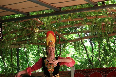
In the Northwest of China, we met another ethnic group, Uyghur, in Turpan, Xinjiang.  There are different stories about the origin of Uyghur.  The common one is that Uyghur migrated from Mongolia into the Tarim Basin around the ninth century.  They assimilated with the local Indo-European population. 

Turpan is an oasis surrounded by deserts.  Water from the Tianshan mountains keeps the life line of Turpan.  Melted snow flows into underground water that travels thousands of kilometers beneath the deserts before reaching Turpan.  For decades, Uyghur people dug long lines of wells and brought underground water to their farmlands and vineyards.  


(Local Uyghur in Turpan) 

(Uyghur girl dancing for her guests in a vineyard)

Turpan was one of the stopping points along the ancient Silk Road.  Travellers and caravans got their supplies there for their long journeys. We are amazed to see that Turpan still maintains rich cultivation of grapes, mulberry and vegetables. 

(Grapes ready for harvest)

2011年2月10日 星期四

China ethnic groups : Bai and Naxi in Yunnan

China has 56 ethnic groups, including the most populous Han people.  So far, we have met about 15 groups in our past travels.  This time, we like to share with you the interaction with Bai and Naxi people in our trip to Yunnan which is in the South-west of China.

Bai people live mostly around the Dali area in Yunnan.  Early in the Tang dynasty, Dali was a local kingdom with Buddhism as its state religion.  Until the thirteenth century, the Mongols took over the Dali Kingdom as part of the Yuen Dynasty.


(Entrance to the Dali old city)

The word Bai means white. The Bai people favour white clothes.  Their buildings are painted with white decorations. The Bai people still farm in the coasts of Erhai Lake.  Many of them have turned into traders.  Tea is their key trade commodity.   The ancient "tea horse road" refers to the trade routes between Yunnan and Tibet regions.  The trade routes have to go through high mountains.  Horses were the means of transportation.


(House of local Bai farmer)
(Bali performers dressed up in local costume)

With two hours drive along the mountainous road, we arrived Lijiang from Dali.  Lijiang is the home of Naxi people.  Lijiang is surrounded by beautiful alpine mountains.  The Jade Dragon Snow Mountain is a popular tourist attraction.  


(Jade Dragon Snow Mountain)

(Lovely Blue Bell flower in the grassland below the snow mountain)

The Naxi people love to dance, including young ladies and old grandmas. 


(Dance with Naxi grandmas)

(Young Naxi ladies dancing in the local fire dance party)

The Lijiang Old Town is now populated with tourist shops and motels.  Tourism business becomes the main source of local employment and economic income.  Eventhough you can still see Naxi people in their local costume, their lives have been significantly changed by the development of tourism.  Similar phenomena are observed in our travel to other homelands of ethnic people.  If you are interesting to explore more on this topic, you can read the following book:  Nyiri, Pal. Mobility and cultural authority in contemporary China. Seattle: University of Washington Press, 2010.


In the follow on posts, we shall share with you about Tujia, Buyei, Uyghur and Hakka people whom we met in our travels.

2011年2月4日 星期五

Hoi An, Vietnam : an old sea port

This time, our cruise sailed from Ha Long Bay to Da Nang in the middle of Vietnam.  From Da Nang, we took a day tour to Hoi An by bus.  Da Nang stands in the middle of Vietnam.  It is facing the South China Sea.  Due to its strategic location, it was used as the US air base during the Vietnam War.

(Cruise landing in Da Nang)

(Have you tried rowing a circular boat?)

As early as in the second century, Da Nang was under the influence of the Champa civilization. The archaeological site in My Son, which is located in the west of Da Nang, unlocks the old Champa temple of Hindu background.  You can find more about this in the book of  Hardy, Andrew (ed.). Champa and the archaeology of My Son (Vietnam). Singapore: National University of Singapore Press, 2009.
Later in the eighteenth century, the Nguyen dynasty reunified Vietnam and built its capital in Hue which is just north of Da Nang.

Hoi An is the old sea port of Da Nang.  Chinese sailors and merchants had settled in Hoi An many centuries ago.  You can find many beautiful Chinese temples and houses of regional trade associations in Hoi An.  In the fifteenth century, Portuguese came to Hoi An as part of its trade route between Macau and Malacca. 

(Local farm market in Hoi An)

(Boat ride for tourists)

(Houses and boats in Hoi An)
 Hoi An has very much kept its old beauty.  Local people seems to be happy with their traditional lives. Until recent years, local government steps up the development of tourism business.  Resort hotels are being built along the sea shore with man-made beaches. 


(Ancestor temple for local villagers)

2011年2月1日 星期二

Ha Long Bay, Vietnam : a cruise to the South China Sea

This is our second visit to the Ha Long Bay by cruise.  The first time was eight years earlier.  Ha Long Bay retains its calm and beauty.  Passengers from the cruise still have to be transported by small boats to the shore. The noticeable change is the presence of more pleasure boats for tourists.


(Pleasure boats waiting for tourists)
 We like the natural beauty of Ha Long Bay.  Nearly two thousand of limestone islets of various sizes and shapes are scattered around the bay.  The calm sea water surface reflects the images of these islets.


In these limestone islets, there are also limestone caves.  Some of these caves have been turned into tourist spots.


Life in the fishermen village remains the same.  Most villagers live in their boats or floating houses.  Fishing and fish farming are their main sources of income.  Recently, tourist business has brought in new income to the villagers.


(Young and elderly fishermen near the shore)

(Fisherman family trying to sell fruits to tourists)

(Sea eagle looking for its catch in the bay)